| life insurance assurance quote click here |  |


Ancient and prehistoric monument in Scholes Coppice, UK.,
Update Friday 13th September 2013
The area of Scholes Coppice attracted attention of various bodies who all helped to make it safe from destruction, at least for the present time. The ancient monument is now under the care of English Heritage and the ancient woodlands are being better cared for. I was told that the trees that had been introduced were going to be gradually taken out and the native trees encouraged. The preservation of this area was the sole reason for beginning this domain and I feel it was successful and we encouraged the awareness of our natural surroundings. This domain is going to be gradually developed now to encompass a wider spectrum of holistic living. This is going to take some time and won't happen overnight as this is my hobby, not my occupation. I'd like to thank all the people who helped, Sorry I took so long to say thank you, it was heartfelt all along
Updated Monday, November 20, 2006These pages were originally made to bring to attention information and developments in, around and about the small Ancient wood called Scholes Coppice.
The Guiding Light of Lao Tzu - a New Translation and commentary on the Tao Teh
Ching translated by Henry Wei
I met with 2 managers in the woods a while ago. This is my report of our meeting
Ancient woodland is endangered in our country. Earthworks are part of our heritage. Immature trees are being felled as they grow back on the field above the woods, the whole area was recently Ancient Woodland. See maps and photos below. The excuse is that the "field" is "grassland" and has been made a conservation area. However, a road through to Scholes and Thorpe Hesley is planned. It was first applied for more than twenty years ago. Ancient woodland has been there for thousands of years, since the beginning of the Holocene -10,000 years ago, and needs no help from us to continue except to be left alone, but it does need drainage which conservationists working for the council have plugged up with gravel. This is because the field has been declared a conservation area, so now is mowed and easier to walk on, also the stream which was fed by the field's drainage system did flow through the other land wanted for development at Thorpe Hesley. The stream that was fed by the culverts is clearly shown as a natural feature on the maps on this page, but it is dried up as my photographs show if you follow the links from this page.
To make it more ridiculous, a game is being played on the field. There is now an area for highland cattle which is fenced off, they eat all the orchids before they flower in February. There is also a small area in the top corner of the field near to the bellpits, now fenced off, where small oaks and other deciduous trees grow, which is to be the home of some sheep!!
An area to the bottom of the field where my photos show bullrushes growing from the culverts is now designated as a wetland area and heather and ivy have been encouraged, they will kill the acid hating natural fauna.
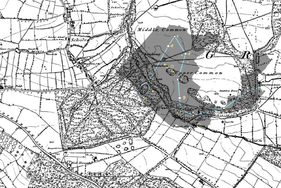
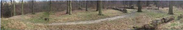
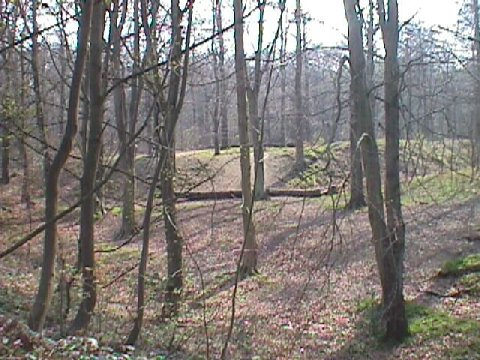
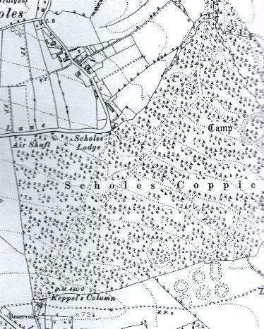
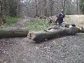
The location of Scholes Coppice is on the outskirts of Rotherham in South Yorkshire UK. The main reason for concern is that the wood contains a Late Neolithic to Mid Iron Age double-ditch earthwork, (I believe it to be a henge), dating to a possible 3,000 years old, under the protection of English Heritage, called "Caeser's Camp" which is in real danger from the people around it, including the local council who see the field above and the woodlands as seperate issues. The long-term plan is to remove mature trees from the monument, leaving roots in situ to prevent turbulence in the soil from degrading the henge. This is normal practice with earthworks but the people responsible have overlooked the issue of a raised water-table. Also the woodlands are Ancient woodlands; therefore need no help from people except to protect them from interference and damage from outside. Clearing mature trees raises the ground water, filling in drainage culverts and felling mature trees does not encourage smaller trees to grow but drowns them. The trees so far felled except for one have not been on the monument itself. Water running off the field now runs in streams directly onto the woods and the earthwork, in effect it is being washed away
Firstly the EARTHWORK in the woods...
In this Ancient woodland are two oval banks of earth which contains a central
bank, sunken in the
middle. It used to contain a level inner table but time has taken its toll. The
bank is surrounded by a deep ditch and further out is a second ditch. As the
earthwork could date from the Late Neolithic it may have been there since the people in this region
were peasant farmers. For many years it was called Caesers camp as the locals
thought it to be Roman, but an exploratory survey by the University of
Sheffield gave me the age I have stated here, later correspondence from the University has dated it as more recent, possibly later Iron Age than was thought as there are stone bases in the ditches, however it is pre-pottery. The character of the monument is similar to henges, having an inner table but it is oval and on a slope. This slope could be the reason why it is an oval shape as it would appear circular from a distance or from the air. Many earthworks such as the ones in South America can only be viewed properly from the air. In the countryside nearby are at least two
very large ridges which are also casually named "Roman" but could be part of
the same colossal earthwork. It could be the site of an ancient meteor impact that was marked by witnesses, a survey for this evidence would be a good idea. Similar earthworks in other parts of the world
date to earlier times, such as those in North America made by Native Indians who were hunter-gatherers.I refer to the monument as a henge as that's what I personally believe it to be.
The center of the henge is situated in the woods, and as mature trees are
felled and culverts for taking excess run off are filled in, it is being
destroyed by water damage. This is also a conservation issue as wildlife and
Ancient woodlands in the area are being irreversibly damaged.
Secondly, the environment....
We need our Ancient woodlands and meadows
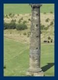
The woodlands were cut back during the 1950's but have also suffered drastic cut back during the last 10 years. The field below Keppel's Column (a folly), has been mown for the last few years causing a reduction in the numbers of nesting skylarks. Highland cattle now graze in an enclosure overwinter killing the rare wild orchids like the one I photographed in 1980's and use a a logo above. Drainage culverts have been filled in causing waterlogging of the field which had rare butterflies and meadow flowers, but now has bull rushes.
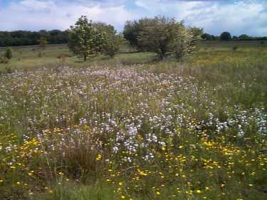
photo www.heritagewoodsonline.co.uk
 This was a photo of the fence built across the field when it was first installed. It was to contain the highland cattle, to the left there is now mown grass and an area of boggy ground and bullrushes, to the right the area is grazed. The previous picture of wild flowers is now mowed and grazed off to ground level.
The historical examples of the effects of these type of changes made by people in the past are very apparent in our moorlands and mountains:
quote from Lancashire Historic Landscape Characterisation Programme 10. ROUGH LAND HLC TYPES page 12 : "Moorland is as much a man-made landscape as any other HLC type. 5,000 years ago most of the current moorland area was covered in woodland. Subsequent clearance, management and animal grazing have combined with the harsh climate and the devlopment of acidic soils and peat to create the moorland landscape visible today."
quote from Chris McIvor LANDSCAPE AND CULTURE page 12:
"At the same time this reconstruction serves to remind us that the physical landscape we see today is a historical creation and one that has impacted for centuries by human presence and activity. Where are the extensive forests of birch, rowan, alder, fir and oak that Gunn describes in the early part of the novel, the wooded valleys and green slopes that allowed him to claim a landscape that was fertile rather than denuded? (3)
As Gunn was acutely aware, the bleak moors and clear cut lines of our local hills and mountains were once clothed in trees, a fact established by historical record and archaeological investigation. What altered them was human agency, the most extreme of which was the seizure of community assets by landowners in the 19th century and the subsequent arrival of sheep that left us with much of the desert that our visitors like to imagine today as unspoiled wilderness."
Obviously putting sheep on the field is going to be devastating.
Please read on
Extra water runoff kills immature trees in the ancient wood below; the effect is increased by felling trees which would otherwise pump out the excess. Unfortunately mowing meadow grass destroys
flowers and habitats of fauna. There are many photographs here of water damage to the Ancient woods and to the Ancient monument in the heart of the wood.
Click on the small photo links to see more:
 Environmentally mismanaged
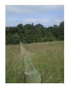
Water damage and filled-in drainage culverts:
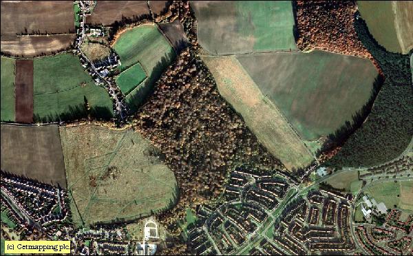 ariel photo within 3 yrs
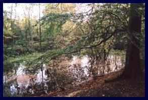 photo www.heritagewoodsonline.co.uk
It describes flora and fauna which was found there, with photos; in particular one of wetland which was fed by water draining from the culverts, which is shown as it used to be (plants and trees link). It is dry now as water runs off directly onto the earthwork area from the field.
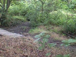 photo taken Monday, August 16, 2004
Just click on the small pics below to access other older photos including views of monument.
 Out of This World! Light effects.
 Summer Solstice 2000 photos
 My first page on the subject, updated in 1998 with photographs taken in Summer showing good views of the earthwork and the damage. I actually went with friends and picked up rubbish, we left notes to the partygoers to clean up and left bin bags which they filled and left us a note of apology.
There was good news about the proposed building at nearby THORPE HESLEY. The 12,00 houses
are not now being built mainly due to action by the local people of the
village. This was good news for the ancient woodland of Scholes Coppice and the
earthwork. Roads for access and increased traffic, also
increased population in the area would have hastened the disintegration of this
very ancient site.
Unfortunately the threat of building and development including a road has resurfaced. ![]()
On the 18 May 2005, Rotherham Metropolitan Borough Council agreed to sell land in the village of Thorpe Hesley that will be used to provide an access road This was agreed without consulting local people who use the land. A planning application to build 600 houses, by Bryant Homes, is expected shortly. The people in the area have been asking why their village green is targeted for these houses when there is plenty of brown area land available in the borough.
This village is adjacent to the village of Scholes which has been reported to have suffered from water problems in several cottages and on their cricket field.
This website addresses the problems with water runoff and a raised water table due to filling of drainage culverts on Keppel's Field above Scholes Village. After communication with the Scholes Village Organisation, (not STAG) I have been asked not to refer to their website or entries in their online news items and have removed the logo and text taken from their reports as was demanded.
I am entitled to include my review of their material which is published in the public domain. Having looked at the copyright laws at this link Government-backed home of UK Intellectual Property on the Internet which says "Fair dealing with a work for the purposes of criticism or review of that or another work must include a sufficient acknowledgement and the work must have been made available to the public".
I am obliged to include a link to their site so that the reader will be able to form their own decisions. Therefore I have constructed another page ![]() HEREwhich outlines water problems in Scholes in recent years
HEREwhich outlines water problems in Scholes in recent years
 For photographs taken early 2000.
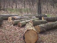
Fire damage,
prolonged felling (not within the 10 year spacing),
and dumping of
building rubbish i.e. housebricks, concrete, paint cans.
For photographs taken early 2000.
Fire damage,
prolonged felling (not within the 10 year spacing),
and dumping of
building rubbish i.e. housebricks, concrete, paint cans.
Click on these small photos to see larger copy.
more are marked for felling
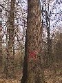
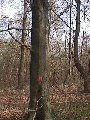
Some marked are definitely not mature trees
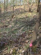
 This is the evidence that more trees are being taken than was specified close
up of
bark details
to distinguish between individual trees.
This is the evidence that more trees are being taken than was specified close
up of
bark details
to distinguish between individual trees.
Your feedback is welcome, for example this Email from someone local to the henge area dated 20 February 2003 21:51 :
"I have found the information about the mismanagement of Scholes Coppice very interesting. Do you live around the local area? How have you made your feelings known to the people responsible? Are you aware that the 'so called' conservation area set aside for wildlife (but grazed by 6 Highland cattle during winter) was recently let to a farmer who proceeded to increase the head of cattle to twenty!! much to the detriment of the 'so called' conservation area. The council threatened the farmer with legal action. The cattle were eventually moved after local residents threatened RSPCA action, after the cattle had grazed off most of the sward and were left without food and water during a recent cold spell."
Send me your points of view, comments or ideas: katy*@holisticfraternity.co.uk (omit star to send,this is to prevent unwanted spam)
A couple of contributions from an interested party are cited here for your
consideration. I would like to add that it really makes no difference to the
problem of preservation of the site if the monument turns out to be Iron Age,
or if popular opinion is that it was a fort. It could quite easily have been
constructed as a henge and used later for defence, much as we see old churches
used as bingo halls. The comments here are intended to demonstrate that the
site is regarded as valuable:
"I quite agree with you about the effect that trees have on the volume of water
in the soil - it would seem that the management plan instituted by Rotherham
MBC is having a negative effect on the woodland and this is certainly something
to be extremely concerned about - having seen how council departments operate
(and having had more than one exchange of letters with Sheffield CC on similar
issues) it comes as no surprise to learn that they are incapable of
co-ordinating a strategy to protect the Ancient Woodland. It must raise
concerns about the fate of other areas of ancient woodland which are currently
the subject of local authority attention."
dated 12 August 2004 16:54
"A contour survey and limited excavation was undertaken at Scholes
Coppice by the South Yorkshire Archaeology Unit in 1991 and the usual types
of 'grey' publications were produced. These are held by the South Yorkshire
Archaeology Service. Sheffield University were not responsible for the
project, although most members of the excavation and post-ex. team had
formerly been students at that institution and Professor Paul Buckland
offered comments on the six sherds of pottery recovered from the site. An
account of the work was published in 'Archaeology in South Yorkshire 1991 -
2'. I believe that this publication is now out of print, but copies are
available in local libraries and in the SMR. The aims of the limited scale
excavation were to investigate the construction of the bank, to determine
the profile of the ditch, to locate and define features within the
enclosure, to investigate the date of the monument and to assess the effects
of erosion. The work was prompted by problems of erosion caused by
inappropriate use of the monument (motor-cycling and mountain biking) and
was funded by Rotherham MBC who hoped to use the results to inform a
management plan for the monument and the woodland as a whole.
The plans, a section through the ditch and a cross-section through the
ditch and bank and a suggested reconstruction drawing were published in AISY
together with the results of the excavation. These were, unfortunately,
limited. There was some evidence for iron working on part of the site in
the form of a large piece of iron slag. Four post holes were found close to
this. Organic material and micro-faunal remains from the ditch suggested
that it had contained standing water prior to silting up. The section
through the bank showed that it had been carefully constructed with layers
of stone overlying a base of compressed clay and a substantial post hole
which extended the entire depth of the bank and cut into the clay prompted
the excavators so suggest that the bank had been topped by a palisade. A
calculation of the volume of material originally excavated from the ditch,
compared to the present height of the bank suggested that more than a metre
had been lost from the latter. The only datable material recovered was six
sherds of abraded Roman pottery of 3rd to 4th century date. These were
recovered from the upper fills of the ditch and cannot be considered to date
the monument as a whole. This is typical of sites of later Iron Age date in
South Yorkshire where Iron Age pottery is rare (as has been discussed on
Britarch previously), although there are obvious dangers in arguing from
such negative evidence.
To my mind there is no evidence that the site is of Neolithic date (it
certainly isn't a henge, or at least, not one of conventional form)** and nor
is there any evidence that it is linked with the Roman Ridge (presumably the
ridges mentioned by the holistic fraternity), certainly it is not part of
the same earthwork. My own opinion is that it is of later prehistoric date
as the Roman pottery in the ditch would seem to suggest that it is not
post-Roman in date (although the pottery could be residual).
Morphologically it does not seem to fit in with the LIA / Early Roman
cropmark landscape and one could argue that it is of EIA or MIA date on
these grounds, although this would be somewhat speculative. The debate over
the date of the Roman Ridge is far from resolved (in spite of an excellent
review of the evidence by a regular contributor to Britarch!) although
excavations by the SYAU have demonstrated that its history is more complex
than has often been supposed and that the existing monument was probably
preceded by a substantial ditch.
These pages were composed using
Arachnophilia
which is free to download subject to careware
** perhaps this illustration is the clue to why it isn't a conventional henge shape; the map of constellation draco fits over the site perfectly